Location of Meeting: Love Circle Park in front of 7405 Love Circle, Fort Worth TX 76135
Meeting was called to order at 12:01PM by Scenic Shores Neighborhood Association President Michael Dallas.
Officers in attendance were:
Michael Dallas, President
Deanne Kearney, Vice-President
Louise Shepherd, Secretary
Absent officers:
Brian Keller, Treasurer
Approximately 35 neighbors attended the meeting.
A brief history of the neighborhood association was presented.
The items on the Agenda were discussed.
A motion to reelect officers was made and seconded. By unanimous vote, all current Scenic Shores officers were reelected for another two year term.
Meeting was adjourned.
Annual Meeting Agenda 2015
Scenic Shores Neighborhood Association
Annual Meeting - October 3, 2015
Resolved Issues:
- Lake dredging.
- Installation of safety wall in center of Jacksboro Highway bridge.
- TXDot Mess on Jacksboro Highway
- Casino Beach Traffic on Watercress - Casino Beach Project cancelled.
Issues Underway:
1) Love Circle Park Revitalization
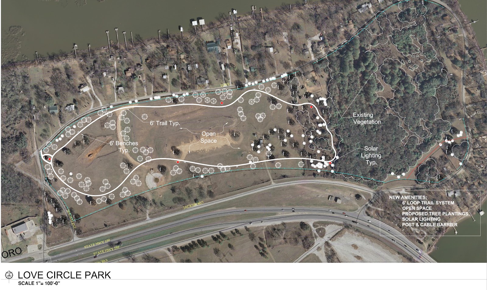
- Completed park cleanup (batting cages, derelict buildings, etc.)
- Installed irrigation and planted 65 trees in Jan 2014. Planted 120 trees in 2015.
- Funding secured in 2015 for improvements (jogging trail, etc.). Work scheduled to begin in 2016.
- No playground / shelter / parking – maintain the site as a passive use open space / naturalized area
- No trail encroachment into the forested area at the south end of the park
- Light levels can be easily modified so that just enough illumination can be provided to observe activity in the park without creating a lighted parking lot’ effect.
- Park encircled with cabling for reduced access to motorized vehicles.
2) Bike Trails
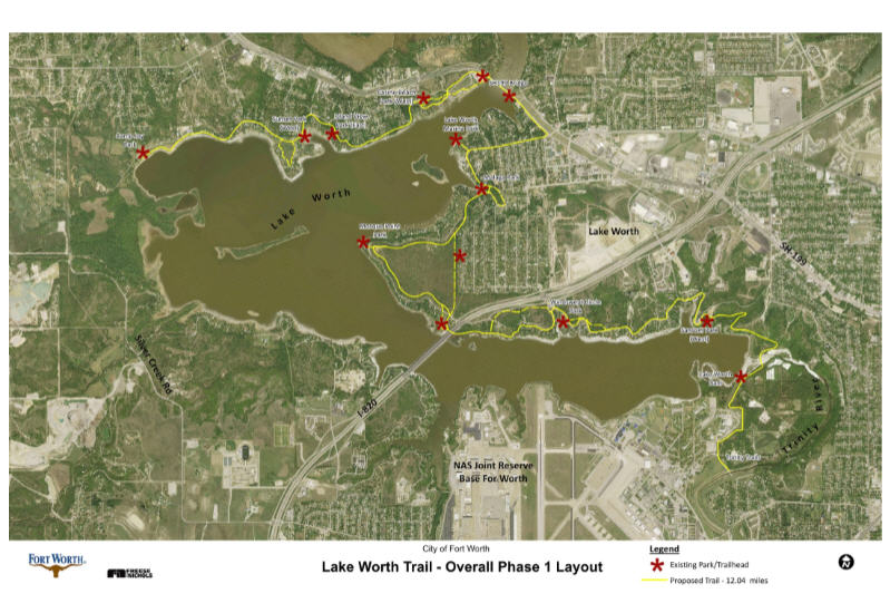
Phase I construction from end of Trinity Trails in River Oaks (e.g. “Burger’s Lake”) to Arrow S Park will begin August 2016.
General estimate of completion of trail around the lake is 2018 to 2019.
3) Water & Sewer
Love Circle (and Surfside) - Design complete. Water and sewer installation in Spring of 2016
Watercress (e.g. Peninsula Club Circle, Island View, etc) - Fort Worth has completed installation of water main. Fort Worth is waiting to connect residents until resolution of Town of Lakeside dispute with Fort Worth over annexation of the Ella Young Addition. Sewer installation estimated to begin in 2018.
4) Jacksboro Highway Corridor Annexation
Fort Worth is 3 years into the process of annexing the area. Currently, Fort Worth is suing Lakeside for a preemptive illegal annexation. Fort Worth expects to complete annexation in 2016.
5) Sunset Park and Peninsula Club Preservation
More work needs to be done to finding agreement between neighbors to create action plan.
6) Crime Fighting Efforts - Working toward a comprehensive plan.
Coordinated Security Plan for Lake Worth
(Working Document - being discussed by other three NA’s)
Purpose of plan: To implement a set of achievable, measurable, and economically feasible goals to enhance the security and safety for lake residents and lake guests.
Security issues: In addition to crime issues common to the entire city, the lake experiences an additional layer of issues. These issues include the vandalism and dumping issues to the extensive park properties, theft of water-specific equipment such as boats and tackle, drowning and injury from lake use, and the increase of all types of crime due to the numerous guests who visit the lake. These issues not only affect the residents of the lake but also the guests who wish to enjoy the lake. For the safety of all citizens, the security in and around the lake is critically important.
Solutions:
Unify park hours around lake - The FWPD has requested that all parks around Lake Worth share the same hours. In its current hodgepodge state of widely varying opening and closing times, policing the park hours is difficult if not impossible by beat patrols. By having all lake parks enjoy the same hours, policing the park hours becomes an efficient and doable task.
Evaluation of infrastructure - Each neighborhood needs to evaluate its infrastructure for needed additions and/or repairs. Infrastructure improvements would include:
Fencing / cabling - Fencing and cabling could be used in a variety of ways including discouraging lake guests from infringing on private property, reduce illegal dumping, and to control traffic damage to natural areas.
Park hours signage - Clearly marked park hours will help policing of the area and reduce undesirable activities which could result in injury or crime.
“On lake” and park location markers - Clearly marked “location signs” would help guests and residents communicate with law enforcement as to the specific location needing service. Location markers would be put in strategic locations in and around the lake.
New park infrastructure - New park improvements should be considered in locations heavily used by the public but which currently lack adequate infrastructure for such use. Proper infrastructure reduces environmental damage and promotes safety.
Evaluation of policing resources - The Fort Worth city government currently expends policing resources for the security of lake residents and lake guests. A fresh evaluation of these resources could result in more efficient use of resources and a corresponding increase in security.
Issue 1: Two police beats - The lake currently is broken into two police beats. Each beat covers not only the lake but also wide swaths of the city.
Issue 2: Lake Marshal - A “lake marshal” currently offices on the shoreline. Once funded by land leases, the lake marshal now finds itself with little or no revenue since the leased land has been sold to lake residents. Moreover, the Marshal’s authority for patrol has waxed and waned between patrolling only the water, to patrolling the land and water, to not patrolling at all.
Issue 3: Confusion in policing - Given the fact that the lake is separated from the main portion of the City of Fort Worth by several communities as well its general rural setting, policing has suffered from confusion. Emergency 911 calls frequently are routed to the wrong municipalities and police frequently cannot find addresses.
Unify policing resources for a “lake beat” - By having a single “lake beat,” issues occurring around the lake can be addressed by a single unified patrol rather than a divided one. This would increase the efficiency of finding addresses as well as understanding patrol issues unique to the lake.
Unify land / water lake patrol - Many policing issues cannot be neatly divided between “water” and “land.” For example, theft, drowning, and safety issues frequently move from shore to lake to shore. Allocate the property equipment and trained personnel to address the issues unique to the lake.
Schedule policing for peak guest times - Like other specific areas of the city, the lake attracts a large number of guests. Allocating resources during peak visiting times would save resources by applying them when needed most. Given the seasonal and weekly nature of the lake’s guests, patrolling primarily should be scheduled for warmer months, weekends, and holidays. Normal residential levels of patrolling should be adequate when fewer guests are at the lake.
Improve communication between police and neighborhood members - Create a better strategy for 911 callers to identify their locations.
Promote home safety practices of individual residents - Lake residents would be encouraged to add “strategic security layers” to protect themselves including:
Lighting
Signs
Fencing
Locking and securing property
Alarms
Cameras
Promote neighborhood-wide safety strategies - Neighborhood associations could engage in neighborhood-wide strategies for increasing their security including:
Neighborhood signage
Neighborhood watch strategies
Educate neighbors on security
Encourage neighbors to report crime
Neighborhood communication
Water Levels on Lake Worth
 People frequently ask "how high can the water go?" There are several answers to this question. To understand the "elevations" of the lake, we first need to talk about the dam.
While the top of the dam is at 594 feet above sea level, the original 1914 design drawings called for the crest elevation (the highest water) to be 606.3. In 1997 the crest elevation of the dam's embankment was raised to 609.5 ft. so that the spillway could pass the probable maximum flood without the dam's embankments being overtopped.
The lake has never come anywhere near the 609.5 level. According to some records, the highest crest was in 1990 when the lake reached 598.7.
Here are the "official" lake levels:
594 - Normal Pool (full to the top of the dam)
597 - Minor Flood Stage
598 - Moderate Flood Stage
598.7 - Recorded high (1990)
Here are some historic high levels:
1990 598.7 - flood stage
2004 597.8 - flood stage
2007 596.1 - 11" under flood stage
At the 596 level, many docks are underwater and some of the homes on the lake are near to getting water in them.
If you live on the lake or are considering a purchase, you should understand the possible implications of high water. It's not a matter of "if" but "when."
(Photo by Angie Myrick Thomas 2015)
Dear Charlie Geren - PLEASE HELP! TXDOT is trashing our neighborhood!
5/8/2015 UPDATE: TXDOT says they will have the site cleared by "mid-Summer." TXDOT said they wanted to continue using the site on a "temporary basis." The neighborhood clearly communicated to TXDOT, Charlie Geren's office, and Dennis Shingleton's office that the neighborhood will vigorously oppose any further industrial use of the site - whether the use is permanent or "temporary."
---------------------------------------------------------------------------
Over the past decade, the neighbors around Lake Worth have put enormous effort into revitalizing the area. Things we have accomplished: $20m dredging of the lake, $80m water and sewer projects, $18m bicycle trails around the lake (underway), numerous park improvements.
One historic park, Love Circle Park, has been the focus of enormous effort. Eight years ago, the park looked derelict. Over that time, we have cleaned the park of debris and planted 200 trees. A jogging trail is scheduled to be installed in 2016.
However, during that time, TXDOT has increasingly used the highway easement adjacent to the park as an industrial staging area. TXDOT's activity is undermining our neighborhood's efforts at revitalization. The TXDOT mess on the highway communicates to the public that no one cares about the neighborhood. This is not true.
We now respectfully ask the Honorable Representative Charlie Geren for help. We ask that he instruct TXDOT to cease from using our neighborhood as a staging ground. Remove the equipment. Remove the gravel. Remove the barriers. Return our neighborhood to us. With all due respect to TXDOT and its important functions, this is our neighborhood. We care about it.
Above, I have included a video. Below, I have a map with the TXDOT area circled in red and pictures of the mess. (The area is just west of where Jacksboro Highway crosses Lake Worth.) As you can see, when the satellite picture was taken, there were only a couple of objects there. Today, the area now looks like a full blown industrial site. Not only is this area in a neighborhood, it represents the "Gateway to Lake Worth." With 50,000 people going by this each day, this area creates the impression most people have of the lake area. This mess is the first impression for anyone visiting the lake or the the Fort Worth Nature Center.


Here is beautiful Love Circle Park, just behind the TXDOT mess.


Subscribe to:
Posts (Atom)